|
A hamlet in the Hundred of Cheltenham 2006
by
Julian Andre Rawes
|
|
Introduction Picture an ancient hamlet nestling amongst cherry orchards, farmland and meadows with a profusion of grasses and wild flowers. There are extensive open strip fields to the southwest, meadows and parkland to the east and farmland to the north. Two ancient high roads meet nearby, graced by an old gallows tree, a stern reminder to passers-by. A small meandering river wends its way through the settlement towards a market town about a mile to the northwest. Many centuries ago the river was leated to serve the ancient mill. Two old timber framed farmsteads stand either side of the river. The old flour mill serves the neighbourhood, and a nine-bedroomed great house along with all the necessary outbuildings to cater for a small estate dominates the settlement. The above description is a picturesque view of the hamlet in the tithing of Sandford as it probably appeared circa 1800. Maybe the description paints a somewhat romanticised view of the settlement; nevertheless it does help to give both a distinctiveness and unity to what is now just another suburb of Cheltenham. In the late eighteenth century, the process of breaking up the old open field systems of Sandford was underway, paving the way for the expansion of Cheltenham. In 1811, the Sandford estate was sold in separate lots. The great house was divided into two and subsequently demolished. In 1822 the ‘new’ Bath Road was cut through the tithing. In 1843, the Boys College was built, followed by the General Hospital in 1848. The new roads of College Baths, Keynsham and Sandford Mill truncated the settlement. Sandford Terrace and the College Baths were built. Sandford Farm was demolished in 1894. Bellevue Farm lost its land, its name and now miraculously survives as a private house hidden under modern stucco. The Mill has been divided up into separate dwellings and adjacent land sold for development. Sandford Road, the Park, the open-air swimming pool, a Victorian house in Old Bath Road and the mill immortalises the name to remind us of a long forgotten hamlet and its ford. The present article was commenced back in 1979 when Murvagh Field, the site of the old settlement, was developed. A watching brief was carried out along with an historical investigation into the origins of the hamlet. The results of the watching brief follows this history.
The name Sandford is first recorded in 1216 as Saunford, by 1605 it is Sand(e)ford(e). Arthur Cardew2 suggested the origin of the name was derived from ‘Sarn’ meaning paved or stony road, but as the area rests on a deep bed of sand there is no reason not to accept that the settlement was named after a sandy ford. There is little doubt that the road leading to and from the ford would have been paved from an early time to ease the passage of heavy transport; in fact both origins of the name could be correct. Sandford was the name of one of the tithings in the Cheltenham hundred. In the earliest Cheltenham Hundred Court Rolls, Naunton, Sandford and Westall are mentioned together as three tithings in the Parish of Cheltenham [Hart. p8]. There is reference on at least two occasions to Manors at Sandford & Westall. There were two footbridges across the Chelt at Cambray and Royal Well, however all local wheeled traffic had to cross the Chelt at either Alstone to the west of the town or at Sandford to the east. This fact alone would have given Sandford a reason to exist. But it is believed that the main reason for Sandford's existence is the ancient north-south highway that crossed the Chelt at this point.
The river Chelt is possibly the main reason for the existence of Cheltenham and is certainly, along with the ancient north south high road, the reason for the existence of ‘Sandford’. The ground on either side of the river rises gently, on the north towards the old Cheltenham high road about a thousand yards away and to the south towards Charlton Park, Sandford fields and the adjacent tithing of Naunton. The Chelt is born on the Cotswold escarpment and flows west for five to six miles until it empties into the river Severn. The river would have originally taken a more meandering and shallower course through the tithing making a small flood plain in a slight valley of sand overlying Lias clay. For most of its course through Sandford the river has been leated or straightened to cater for Sandford and Cambray (Barretts or Cheltenham Mill) Mills. The river would probably have been leated before 1086 when the Domesday Book mentions five mills of which Sandford and Cambray are believed to be two. The Domesday Book appears to indicate that there were two mills in 1066 and five mills by 1086. The modern river course enters the Sandford area about a quarter of a mile to the east at the eastern end of Cox’s Meadow. It flows to the north of the Meadow, past Sandford Mill, under Sandford Bridge or culvert, to the north of the site of the Great House and Farm, under Keynsham Road and into Sandford Park, acting as the park’s northern boundary, until it reaches the Cambray Mill. For much of this stretch it is leated to the north and slightly higher ground. Cox’s Meadow is an area of land bordered to the north by the Chelt and Mill, to the west by the north-south road (Old Bath Road), to the east by the Lilly Brook and to the south by Reeves field, a sports ground belonging to Cheltenham College. The Lilly now joins the Chelt via a sluice at the eastern end of the meadow. The 50" O/S map shows the united rivers continuing in a meandering fashion for about two hundred yards before heading in a straight line for the Mill. The Chelt’s original course would have been through Cox’s Meadow where the natural lie of the land is lower. The Lilly originally joined the Chelt in Cox’s Meadow. The changing of the course of the Lilly may well have taken place considerably later than that of the Chelt. This course probable continued to be used to carry away excess water during wet seasons. Until a few years ago the old course of one or both rivers could still be detected crossing the meadow in a line towards the site of the old ford. This observation is supported on pre-twentieth century maps. The (OS 1888) map shows the old course enhanced by a line of trees, possibly willows, and the Charlton Park boundary line which at this point meanders across Cox's Meadow in such a way as to indicate the original course of the river. Around 1980, due to the collapse of an old tunnel, a trench was cut in the road near the site of the old ford . The tunnel was aligned in a northwesterly direction between the old river course and the Chelt, and probably once either channelled the old route of the Lilly, or was used to drain excess water from Cox's Meadow. There is also a further leat to take unwanted water from the millpond around the north side of the mill. The present bridge is almost certainly to the north of the original Ford. After the bridge, the river continues a meandering course to the north of the present College Baths and Fire Station. The area between the river and the settlement was called Sandford Dread, probably denoting wet or boggy ground. The deep depression alongside College Baths Road, noticed during the development of Murvagh Field, may have been an attempt to isolate the settlement from this marshy area or perhaps may even be an original course of the river. After flowing under Keynsham Road, the river enters Sandford Park where it acts as the park’s northern boundary. Again however the lie of the land suggests the river’s original course lay somewhere through the centre of the Park. About a hundred yards into the Park, the river turns slightly to the south and then to the north west. It is possible that this indicates where the leat for the Cambray Mill starts. The southern boundary of Sandford Park may also echo the river’s meandering course. It must be emphasised that even the unleated stretches, which apparently follow the Chelt's original course, would have been altered almost beyond recognition by deepening, and the raising of banks. The river would originally have been much wider and shallower than now with wide tracts of meadow lands either side. In the nineteenth century two serious floods took place. One in 1830 and another on Thursday the 26th of July 1855, graphically described by 'Goding' (p608) “after many hours of heavy rain a culvert at the upper mill in Charlton Kings burst and a virtual tidal wave swept down through Sandford, Bath Road, Rodney Road, Regent Street, The Promenade, Royal Well and Jessops Nursery, and on to Alstone. An area up to two hundred yards wide was affected.” Although small, the river's unpredictable nature over the centuries posed a natural barrier to the southward expansion of Cheltenham.
The highway passes to the north of Sandford and runs through Cheltenham as the High Street and roughly parallel to the Chelt. The course of the road runs eastwards towards Charlton Kings and beyond. To the west it merges with the 18th century Tewkesbury Road.
This highway crossed the ford at Sandford and the east-west highway 1000 yards to the north. It may be very ancient, possibly British. It is very difficult to date old roads, there are many pitfalls and it is easy to jump to conclusions by assuming straightness and alignment as an indication of age. The route extends or extended at least from Prestbury in the north, ran via Bouncers Lane, Priors Road and Hales Road. The lower part of Hales Road was originally called Hangman's Lane. There is a delightful description of the lane in 'Reminiscences of my Life' by John Bowen, published in 1992 by the Charlton King's Local History Society. "The other road skirted Coltham Lane formerly called Hangman's Lane, and an old oak Tree which stood by its side was called 'Gallow Oak', from a belief that condemned criminals were executed upon it. The said Lane lay very low between high banks, and in a wet time I have seen it up over the horses knees in water. In 1846, Oct. 8th the lane had been converted into a fine broad road under the supervision of Mr Hale (Mr Charles H. Hale, the Parish Surveyor), and with great ceremony, with a band of music, was opened to the public, and named Hales Road . . .". The problems from which Hangman's Lane suffered were only too common. Sunken lanes litter the countryside, especially on slopes where rainwater accelerates the process. In this case there was no bedrock near to the surface therefore the trampling of many thousands of hooves would carve an ever-deepening trench. As the centuries passed by conditions would steadily deteriorate. The lane would sink deeper and deeper, travellers would complain of being stuck in mud and knee-deep effluent from horses and cattle. The lane would be periodically cleared and the waste thrown up on to the banks. Although this action would be of temporary help, in the long run it would only deepen the lane. The lane would get deeper and muddier and smellier while the banks perhaps topped by trees and hedges, would get higher. There was a large open field (Coltham Field), to the east on ground rising away from the lane. It is here that Cotham Farm stood, or indeed might still stand in the guise of number 6, Rosehill Street. If the lands on the upper slope were ploughed then the lane would act as a convenient drain for silt and rainwater. The book also describes a parallel lane called Coltham - an 1856 town plan appears to show the two tracks. The tracks split with one making a dip to the west as if to avoid an obstacle, then returning to join the other track near the gallows. Because Coltham Field was to the east I believe the eastern lane was 'Coltham Lane while Hangman’s Lane was perhaps the eighteenth century’s answer to the problem - a new perhaps paved lane running, in this case, high up on the western bank of the old lane. So there would be two lanes, one for cattle and one for folk. A good example of this is to be found in the upper reaches of Timbercombe Lane off the Cirencester Road where there is a cobbled track created, in part, on the east bank of a classic sunken way. This was one of the eastern routes out of the valley to London. During the building of the new road by Mr. Hale, several Roman coins were found including one of Emperor Claudius. Hangman’s Lane got its name either from the nearby Gallows oak situated on the junction with Cheltenham Street, or possibly from lands put aside for the maintenance of the Gallows. 'Gallows lands' is a description given to land put aside for maintenance of such gallows etc.
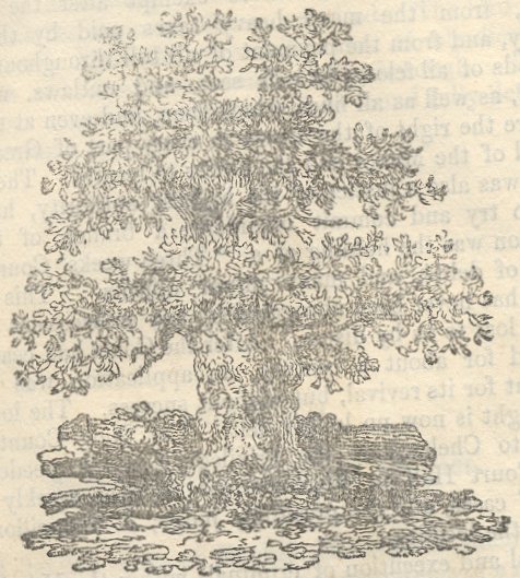 The oak appears to have stood on the southwest corner of the London Road/Old Bath Road corner. Above is a reproduction of the oak taken form Goding's 'History of Cheltenham' who goes on to write: "... In the grant of the Manor to the Abbey of Fecamp in the fourteenth century, the expression "Gallows lands" twice occurs." It is to be noted that the gallows stood on the boundary between two parishes e.g. Cheltenham and Charlton Kings. A Turnpike called (Gallows Tree turnpike) was situated on the northwest corner of the present junction. The old road continued over the junction into the present Old Bath Road. Arthur Cardew in his article on moats published in 1898 [BGAS v21], called this stretch 'Sandford Street'. The street or highway slopes gently down towards the ford and passes the old Bellevue Farm on the left before it comes to the Chelt. A ford obviously existed here and has been commented on by Sawyer and others. One Victorian writer described how he had looked over the parapet of the then bridge and eyed Roman stepping-stones crossing the river. How he knew or thought the stones Roman is lost to us. Although Old Bath Road that crosses it implies it carried traffic to and from Bath and of course it did from at least the time when Cheltenham was making itself known as a spa, its main function was to act as a vital communication link with the parish lands, villages and routes to the south. The river is now a culvert and the road surface flat gives no indication that a ford or bridge had existed. The road continues between Cox's Meadow on the left and the old Murvagh field where Sandford farm once stood, on the right. There is a junction on the right where Sandford Road joins Old Bath Road. Sandford Road was a field road joining Sandford to the Suffolk area where Gallipot Farm once stood. Opposite the Sandford Road junction is the field boundary between Cox's Meadow and lower Reeves field, once part of the Charlton Park Estate. About twenty-five yards further there was a major fork in the road once marked by a large tree and a roadside hand & post. There is now no indication that such a junction ever existed. The eastern fork took a meandering line across Upper Reeves Field and on across Charlton Park towards Withyholt Farm. Here it joined Sandy Lane that climbs over Charlton Common, past Severn Springs and on into the Churn valley towards Cirencester. The map of 1776 shows the lower stretch of the old road in fine detail. Returning to Old Bath Road and a short way further on there is on the right the junction with the present Thirlestaine Road. This was another field road and connected the Westall tithing with Sandford.
More details concerning some of the people mentioned in the following items appear in the chapter on the people of Sandford. “Sandford in which and in Naunton are 5 houses, Thomas Dingley and Phillipa his wife were seized of the Manor of Sandford and of lands in Cheltenham and Elizabeth (only daughter of Thomas & Phillipa), who was married to George Barrett. George Barrett and his wife do jointly sue out livery of these lands. 9 Hen VIII.” From the preceding item recorded by Robert Atkyn’s in his ‘Ancient and Present State of Gloucestershire’, 1712, it is clear that at least by 1518 there is a hamlet at Sandford. How long that settlement had been in existence is impossible to say, but the indications are that it was considerably older than 1518. Norden’s survey of 1617 states that the following people held house in Sandford: John Currier, Margaret Ireland, John Powell & Anthony Higgs. Fosbrooke in his book on Gloucester, records the marble monument in the Cathedral to James Wood who died in 1761. “He was descended from the family of the Woods of Brockrup Court and Cheltenham.” This is probably the family recorded by Rudder as owning Sandford in 1803. Ralph Bigland records: “In 1779 John de la Bere purchased of the Earl of Essex ……. All the Tithes and Glebe of Westall, Naunton and Sandford with those of his own Estate in Alstone.” He then says concerning the three above hamlets:- “ The former is the sale property of John de la Bere between whom Doddington Hunt Esq. and the families of Wood and Higgs, the others are divided.” The above ambiguous sentence suggests that the Woods & Higgs families were at Sandford at this time. Rudge, in his history of Gloucestershire, 1803, records that James Wood Esq. of Gloucester owned Sandford which had been in the family for two or three centuries. “About ¼ mile from the top of the street the road divides, the one on the right leads through Sandford Fields to Leckhampton Hill. Before you come to it on the left is a large brick house in the middle of a park. (Presumably Charlton Park), the residence of Doddington Hunt, Esquire.” Mitchell’s map of Cheltenham in 1806 is the first to show Sandford with its three individual houses on the future Murvagh Field as they appear on later maps: that is, the L-shaped Sandford House, with Sandford Farm and Sandford Cottage (adjacent to Sandford Farm), on the north side of the river; and the Mill and nearby Bellevue Farm on the south side as shown in detail on Merrett’s map of 1834. Of the area later called Sandford Fields much was partitioned into open field strips. Many years ago I was offered an old parchment agreement over the sale or rental of one of these strips and to my regret refused it. Between the years 1721 & 1759 eight selions of arable land in Sandford Field was purchased from Edmund Ballinger.
As 'Bigland' records in 1779, John De la Bere purchased from the Earl of Essex all the tithes which supported the perpetual Curacy of Cheltenham, and also the tithes and glebe belonging to the hamlets of Alstone, Westall, Sandford & Naunton. The Clerical property in the hamlets eventually passed to his son the Rev. John De la Bere. Further details of Sandford’s field system along with a plan, is to be found in Rawes: Fields & Field Names of the Hundred of Cheltenham, published in the journal of the Cheltenham Local History Society. By 1800, the hamlet comprising mill, Bellevue Farm, Sandford House/Villa and Sandford Farm has changed little. The area is still sleeping amongst the fields that have surrounded it for centuries, but times are changing, a great change is taking place in those fields surrounding Sandford. Major landowners like John De la Bere are spear-heading that change by buying up the individual strips owned or rented by local folk and amalgamating the strips into larger plots. Great money is soon to be had as plot by plot the land is sold for development. The lands nearest to the town were first to be developed as Cheltenham finally vaults the Chelt and rolls over the present Bayshill, Imperial Gardens, Oriel Road and the area around the old Mitre public house. Then came the building of Montpellier, Westall Farm went to make Lansdown, Gallipot Farm to make Suffolk. Cheltenham also gradually spread further along its high street and cut into the Bellevue Farm land along the southern side of the present London Road. The laying of Bath Road in 1822 would have gone a long way in opening up Sandford Fields for development. It is interesting to note that almost all roads crossing the Chelt did so to reach either a mill or a spa:- Old Bath Road Highway and Sandford Mill Keynsham Road pumping station College Road Charybeate spa Sandford Park Cheltenham Mill also possibly including an old track leading south. Bath Road Montpellier spa & baths Wellington Street nothing obvious. Rodney Road Cambray spa The Promenade Imperial spa Old Well Walk the original spa and also an ancient track foot crossing. New Street Upper Alstone Mill Gloucester Road tram road, old road to Gloucester Arle Avenue/Mill Lane Lower Alstone Mill
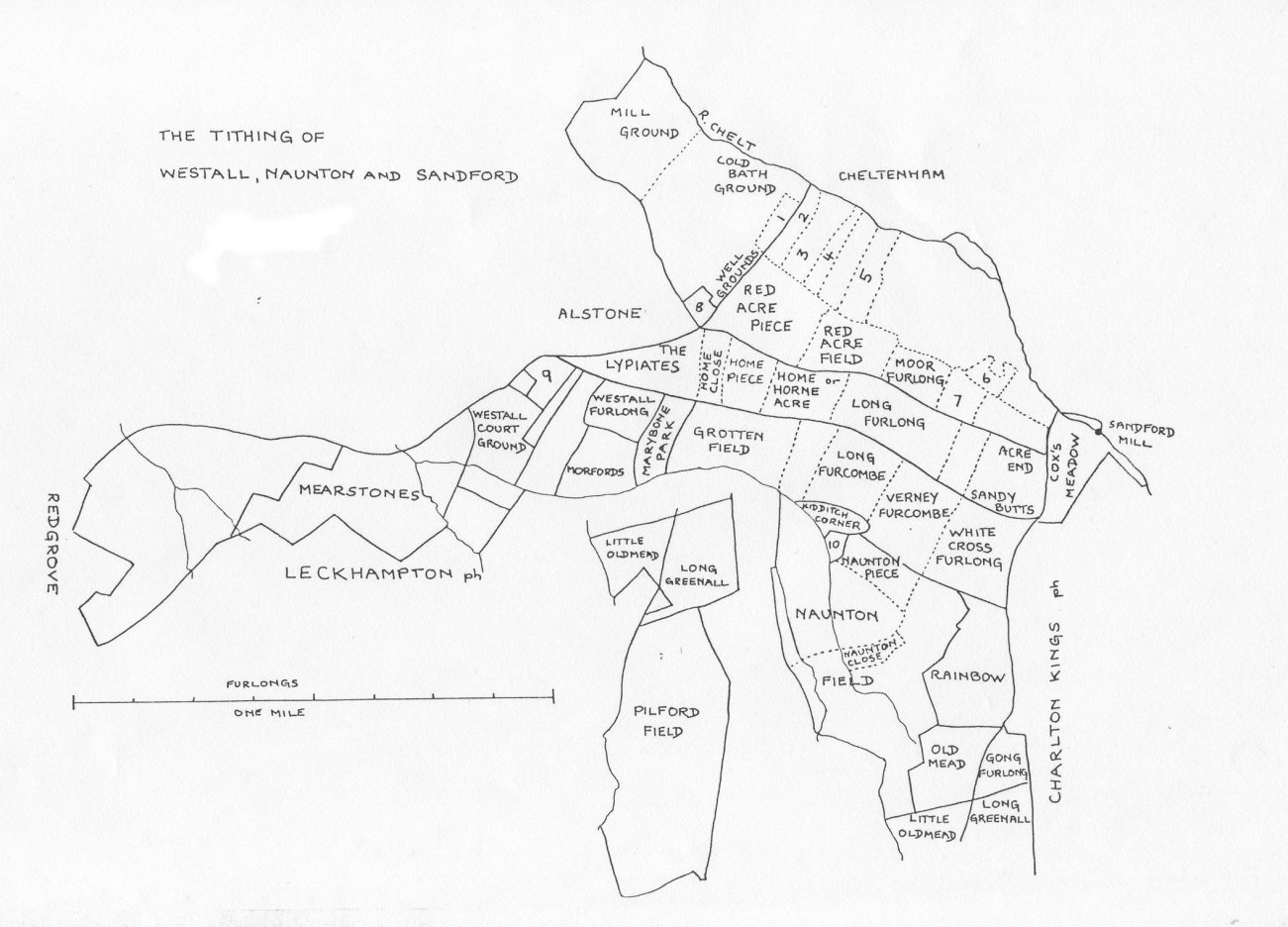 In 1988, Barbara Rawes wrote an article on the field names of the Hundred of Cheltenham. One of the plans produced was of the fields that made up the tithing of Westall, Naunton and Sandford at around 1750 (Cheltenham LHS, Jnl.6.). The plan identifies the Mill and Cox’s meadow. Looking closer one can see the predecessor of Sandford Road dividing Moor Furlong from Long Furlong. The predecessor of Thirlestone divides Sandy Butts and White Cross Furlong. The name White Cross survives as Whitecross Square.
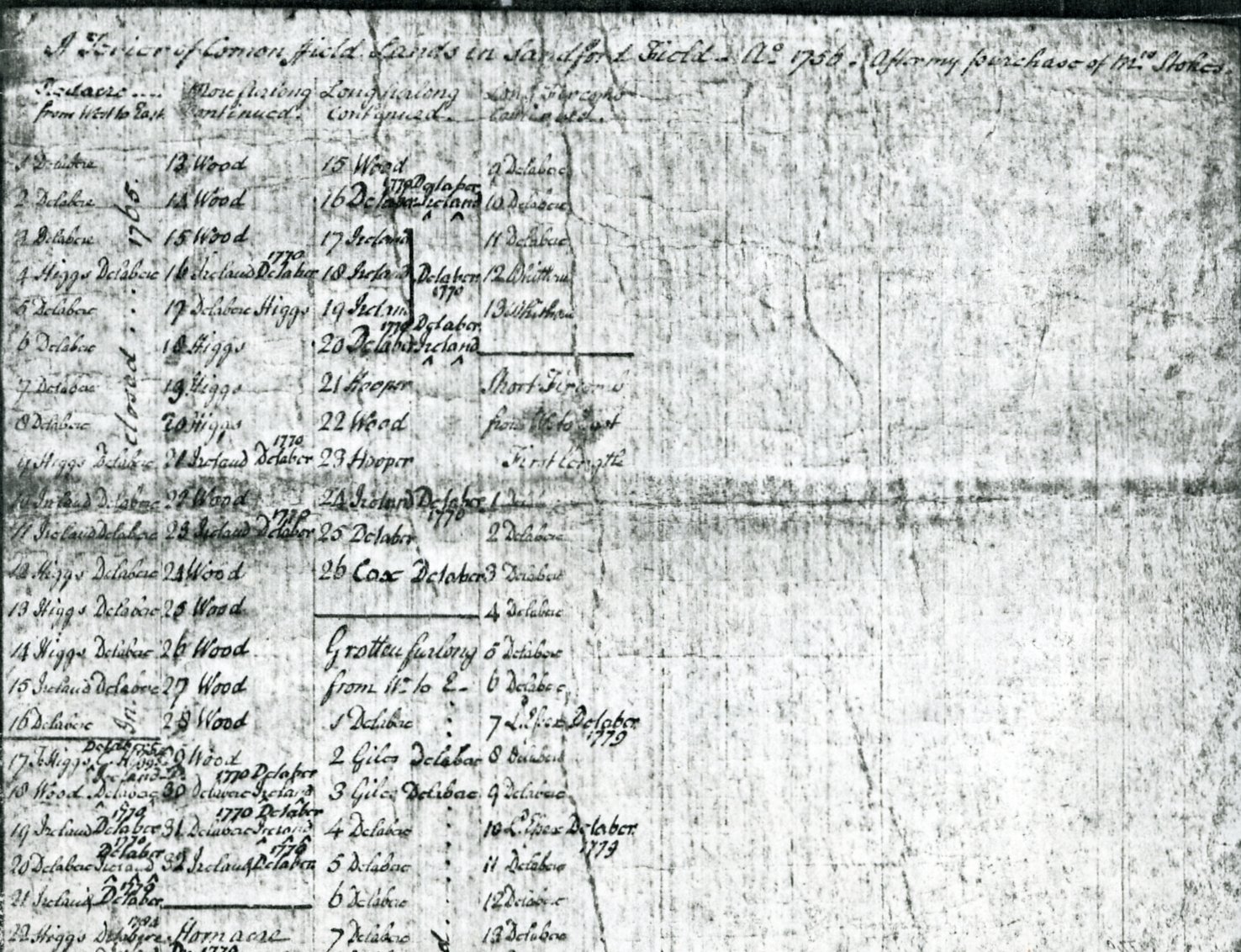
Below is a transcription of a terrier relating to Sandford in the possession of Mr Baldwin of Charlton Kings. This invaluable document was probably part of the 'De la Bere papers. The document relates to 4 fields of Sandford: Redacre, Morefurlong, Longfurlong, fields that are depicted on the above plan. A terrier is a document that records the apportionment of land between different owners or tenants. In this instance the terrier records the ownership of the 153 strips that went to make up seven open fields. The terrier presents a picture of rapid change to the land. Large blocks of land were coming under single ownership. By 1756 the De la Bere family is the majority landowner and later additions show the old Sandford families of Higgs & Ireland selling out to the De la Bere estate. The Wood's being the owners of the Sandford estate appear to continue their ownership until they sold the estate in the early nineteenth century. Where there are two names against a particular strip it indicates that the strip has been sub-divided. The terrier also records the direction in which the strips lay, an example being the strips in 'Redacre' were counted "from west to east", therefore indicating that the strips ran north-south. |
A Terrier of Common field Lands in Sandford field - Ao 1756. After my purchase of Mrs Stokes.
Redacre .... Morefurlong Longfurlong Long Fircomb
from West to East continued continued continued
1 Delabere 13 Wood 15 Wood 9 Delabare
1770 Delaber
2 Delabere 14 Wood 16 Delabere-Ireland 10 Delabere
3 Delabere 15 Wood 17 Ireland Delaber 11 Delabere
1770 1770
4 Higgs Delabere 16 Ireland Delaber 18 Ireland 12 Whithorn
Do
5 Delebere 17 Delabere Higgs 19 Ireland 13 Whithorn
Do
6 Delabere 18 Higgs 20 Delabere Ireland -------------
7 Delabere 19 Higgs 21 Hooper Short fircomb
8 Delabere 20 Higgs 22 Wood from W to East
1770
9 Higgs Delabere 21 Ireland Delaber 23 Hooper First length
10 Ireland Delabere 22 Wood 24 Ireland >b>Delabere>/b>1 Delabere
1770 1770
11 Ireland Delabere 23 Ireland Delabere 25 Delabere 2 Delabere
12 Higgs Delabere 24 Wood 26 Cox Delabere 3 Delabere
13 Higgs Delabere 25 Wood ----------------- 4 Delabere
14 Higgs Delabere 26 Wood Grotten furlong 5 Delabere
15 Ireland Delabere 27 Wood from W. to E. 6 Delabere
16 Delabere 28 Wood 1 Delabere 7 L.E?sexDelabere
-------------------- 1779
Delabere 1784
17 T.Higgs C.Higgs 29 Wood 2 Giles Delabar 8 Delabere
Ireland D. 1770 Delaber
18 Wood Delabere 30 Delabere Ireland 3 Giles Delabar 9 Delabere
1770 1770 Delâber
19 Ireland Delabere 31 Delabere Ireland 4 Delabere 10 L.E?sex Delaber.
1770 Delaber 1776 1779
20 Delabere Ireland 32 Ireland Delaber. 5 Delabere 11 Delabere
1770
21 Ireland Delaber ------------------ 6 Delabere 12 Delabere
1784
22 Higgs Delabere Hornacre 7 Delabere 13 Delabere
Ireland-D.1770.
23 Wood Delabere from W to E 8 Delabere 14 Delabere
1770 Delabere
24 Delabere Ireland 1 Ireland Delabere 9 Delabere 15 Delabere
1770
25 Ireland Delaber 2 Delabere 10 Delabere 16 Delabere
Delabere 1784
26 Ireland Higgs 3 Delabere 11 Delabere 17 Delabere
Do.
27 Delabere Higgs 4 Wood Delabere 12 Wood Delabere 18 Delabere
28 Higgs Delaber 5 Higgs Delabere 13 Delabere 19 Delabere
29 Wood Delabere 6 Delabere 14 Delabere 20 Delabere
Delaber
30 I.Higgs C.Higgs 7 Wood Delabere 15 Delabere 21 Delabere
Do.
31 T.Higgs C.Higgs 8 Wood Delabere 16 Delabere 22 Delabere
Do. ------------------
32 Delabere Higgs 9 Wood Delabere 17 L.E?sex Delaber. 23 Delabere
1770 1779
33 Ireland Delabere 10 Wood Delabere 18 Delabere Wood 24 Delabere
Delabere
34 Delabere Higgs 11 Delabere 19 Delabere Wood 25 Whithorn
Do. ------------------------
35 Delabere Higgs 12 Higgs 20 Delabere Wood 26 Whithorn
36 Wood Delabere 13 Higgs 21 Wood 27 T.Higgs
1764
37 Wood Do. 14 Higgs 22 Delabere Wood 28 T.Higgs
-------------------
38 Wood Do. 15 Wood 23 Delabere Wood
39 Wood Do. 16 Hooper 24 Delabere Wood
1770
40 Wood Do. 17 Ireland Delaber 25 Delabere Wood
1770
41 Wood Do. 18 Ireland Delaber 26 Delabere Wood
42 Wood Do. ---------------------- 27 Delabere
43 Wood Do. Long furlong 28 Delabere
44 Wood Do. from N. to So. 29 Delabere
1770
--------------------- 1 Ireland Delabere 30 L.Essex Delabere
More ffurlong 1779
2 Delabere Higgs 31 Delabere
from west to E:
3 Delabere Higgs ------------------
1 Ailway Delabere 4 Wood
1777
2 Ailway| Do. 5 Wood Long fircomb
3 Wood 6 Wood from N. to So.
1770 1770
4 Ireland Delaber 7 Ireland Delabere1 Delabere
1770 Delaber
5 Higgs 8 Delaber Ireland 2 T.Higgs
1770 Delaber
6 Wood 9 Wood 3 Delabere
1770
7 Ireland Delaber 10 Higgs 4 Whithorn
1770
8 Ireland Delaber 11 Higgs 5 Delabere
9 Wood 12 Higgs 6 Cox Delabere
10 Wood 13 Wood 7 Delabere
11 Wood 14 Ireland Delabere 8 Cox Delabere
1770
12 Wood
Set vertically between the columns is written alongside the relevent furlongs:
|
||
 Terrier. 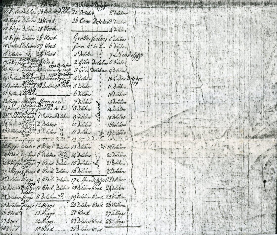 Terrier. 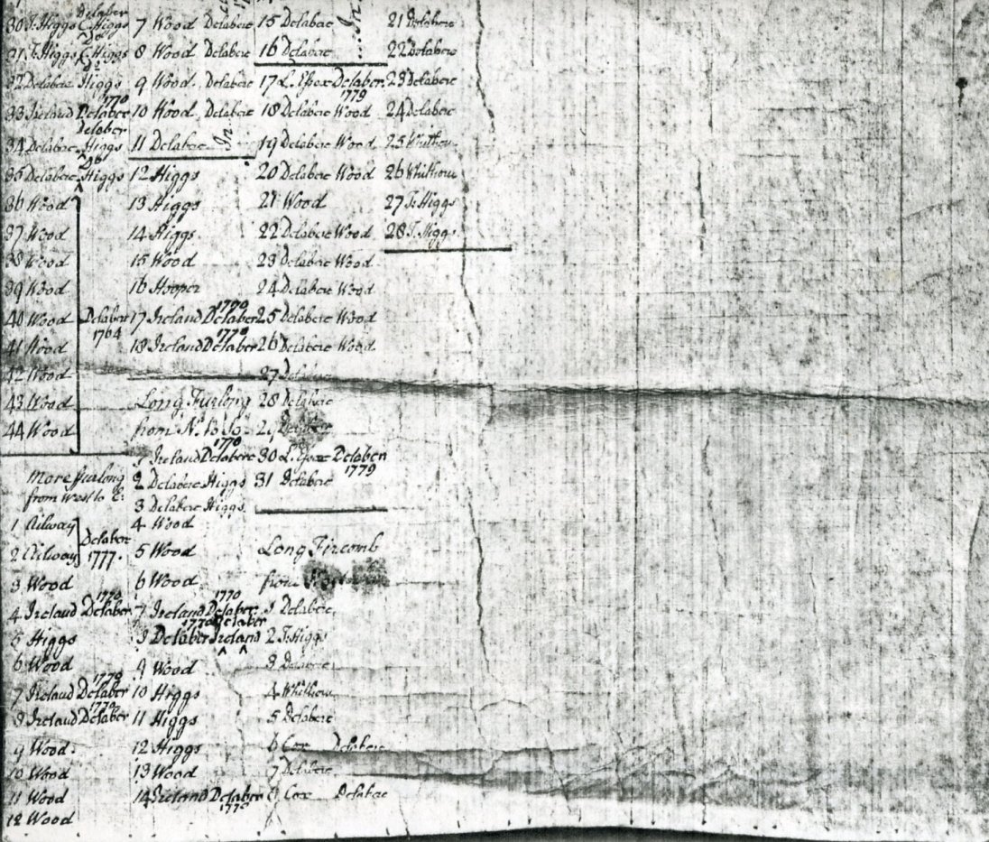 Terrier. | ||
|
The College moved from the Bayshill area to its present site in Sandford Fields in 1843. The College gradually became and indeed still is the major landowner in Sandford. The playground behind the College was purchased in three north-south aligned stages. The middle stage was acquired in 1843. The western section was bought from Lord Northwick, the owner of Thirlestaine House. The last and eastern section adjoining Sandford Lawn was acquired in 1855 and was once a market garden noted for its raspberries. A section in the present railings on Sandford Road indicates the change in the original division. Boyne House, the College Boarding House on the corner of Sandford Road and College Road was built in 1843 by a Boarding House Company and acquired by the College in 1889. The grounds of Boyne House were bought separately in 1900. This same company also built Christowe, Leconfield, Teighmore (next to Christowe), and Cheltondale. The College bought the above properties in 1898. The eastern half of Murvagh Field was acquired in 1884 and the western half including Sandford Farm was bought in 1893. Hazelwell in College Road was built in 1866 and bought by the College in 1902. The ground opposite and below the Music School in College Road was purchased in 1924. Also in 1924, H.W. Reeves OC. gave fifteen acres of Charlton Park alongside Old Bath Road to the College. (Hence Upper & Lower Reeves Fields). In 1931, The College acquired an additional 25 acres of Charlton Park. 4 acres between Keynsham Road and Cheltondale Lane was bought in 1901. This little used land was used as allotments during the first World War and became part of Sandford Park in 1927. A section of it was used to build Sandford Swimming Pool. In 1940 the College bought Linton House in Thirlestaine Road. In 1942 No.2 Cheltondale Villas was purchased ( it already owned No.1). Sandford Lodge in Thirlestaine Road was purchased in 1946. In 1947 it purchased Thirlestaine House, followed by Chandos Lodge, Roseleigh East and Roseleigh West. The College at one time owned property in Leckhampton Road, Suffolk and Montpellier.
In the early seventeenth century, the mill belonged to the Pates family , although 'Men & Armour' has William Wayte as Miller. Mrs. M Paget wrote a history of , along with other mills in the area, of Sandford Mill, published in the Charlton Kings Local History Society, bulletin 21. The present building has a date of 1780 on the outside although the building looks older in parts. In an act of 1786 James Arkell is described as the Miller. In Harper's guide of 1843 James Dunn is described as 'miller'. The Cox family have owned the Mill until within the last five years (1979)
 Sandford Mill in 1804. Published in the Charlton Kings Local History Society bulletin No.21. Original in Cheltenham Museum.
.
   Annuaire 1906 - Mr F Waghorne.
   Kelly    1938 - Geo Cox Farmer.
   Kelly    1948 - Geo Cox Farmer.
   Kelly    1955 - Geo V. Cox Dairy Farmer.
It has since been converted into three dwellings with further development in its grounds.
 Taken in the 1980's, by Bernard Rawes. It stands about four hundred yards east of the bridge. It was bounded on the north by Castle Field (an orchard in 1887, developed in the 1960's), and on the south by Cox's Meadow. Until recently there was a large millpond at the rear of the building.
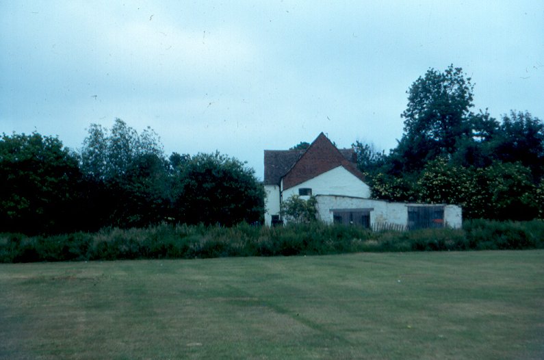 Taken in the 1980's, by Bernard Rawes. An extract from my father's notes: "After a visit to take photos on 22-03-83. I met Mr - - - - who invited me to look around. He told me that his family had owned the mill since 190- and before that it was in possession of 'in-laws' called Cox. He had been able to find out very little about the history of the mill or the manor, having been to the PRO London and Cheltenham Museum. He said the deeds were with the 'Convent' that go back before his family got possession. He has 'new' deeds. The water wheel was sold for scrap in the 1914-18 war. The pool is filled up and one can see the top of the blocked-up brick arch."
The meadow was not as it appears today (pre 2005) and was until the 20th century divided by the Lilly, which acted as the northern boundary of Charlton Park. The southern portion i.e. inside the Charlton Park boundary showed signs that it was once ploughed into open strips similar to other sectors of the park. The meadow has also lost its northwestern tip by the creation of Sandford Mill Road. The meadow is now owned by Cheltenham Borough Council and was used for fairs etc. It acquired its name from the Cox family who worked the mill for many years. There is a tradition that Edward IV's army camped for the night on the meadow prior to the battle of Tewkesbury. The army, consisting of 3000 infantry and a large body of horse, had been on a forced march from Chipping Sodbury. It is said that they descended into the Cheltenham area from Birdlip, camped for the night and then moved on for another night at Treddington before engaging their adversary Richard Neville, Earl of Warwick at Gupshill near Tewkesbury on the 4th of May 1471. If King Edward's army did spend the night at Sandford then almost certainly the neighbouring dwelling houses would have been requisitioned and the inhabitants would have, whether they liked it or not, probably not, played host to those not wishing to spend the night in a field. At the time of the battle the weather had been warm and dry although a heavy mist had settled around Tewkesbury. In the mid-nineteenth century there was talk and a good deal of argument about the setting up of sewage works on the meadow but the plans came to nothing.
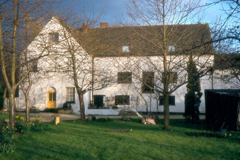
Situated on the north bank of the river and eastern side of Old Bath Road is the Bellevue Farm house. At one time (Tithe Award), it was the centre of a 400-acre farm, including the area covering the present Sandford Park. The western section between College Road and Keynsham Road used to be known as ‘Turner’s Field’. Presumably the old Bellevue Hotel in the High Street and Bellevue Lodge on the corner of College Road and London Road are named after the Farm. For many generations the property belonged to the Higg's family of whom one member financed the building of Holy Apostles church. In the last century, after Bellevue had ceased to be a farmhouse, it was called 'Sycamore House’; its current name is ‘Abbotsford'. The building is camouflaged by modern stucco but structurally the house, in part, dates back to at least the seventeenth century when the deeds commence. Footings of other buildings have been found in the garden and during the conversion of the old coach-house, possibly the original farm barn, a slate fire back bearing initials of a member of the Higgs family and a date around 1700, was uncovered. The slab was sold and was in 1979 to be found in the backyard of The Plough public house, Prestbury. The fireback was stolen from the Plough in 2000.
In BGAS, transactions XXI 1898, there is an article on Gloucestershire's moated sites written by Arthur Cardew. He is the first and only writer that I know of to mention the possibility that there was once a moated site at Sandford. He writes: - "An old resident in Sandford Terrace told me that he personally knew that a moated house stood on the land behind the terrace and that it was not filled up when he was a boy sixty years ago. It was on the south side of the Chelt near to the Sandford on the Sandford Street or Old Bath Road". Sandford would have been a very likely candidate to have a moat for drainage if not for defence. There is close proximity to water as the settlement lies near the river. The site may well have been periodically subjected to flooding as was nearby Cox's meadow. There are similar sites in the area at Prestbury, Leckhampton & Uckington. Observations during development on the eastern half of the site, despite many service trenches, failed to show any evidence of a moat. There was a large and deep depression just to the west of the farmhouse but this appears to be a pond and did not encircle the farmhouse. If there was a moat then the most likely position would have been around the Great House. The "old resident" remembered the moats existence some sixty years before 1898 which would take us back to the 1830's just before the old house was demolished. Merrett’s map of 1834 however, gives no indication of a moat. Unfortunately the development of the area around the site of the Great House was not inspected so the question remains unresolved.
At some stage at or subsequent to 1811 when the estate was broken up, a major division took place that divided the settlement in two. The property division between the old Murvagh Field on the one hand and Murvagh and the land on which Sandford Terrace was subsequently developed was created. This boundary cut through and divided the Great House. The eastern side of back lane of the Terrace represents that dividing line. Sandford Terrace was built in at least two stages. By 1840-42 two thirds of the Terrace had already been built and by 1841-7 are occupied. The Terrace now consists of 16 houses. One of the houses, probably ‘Broxted House’ on the corner, was once a pub called the Cricketers Arms.
The Cheltenham College Register of 1928 records that in 1894 two ancient houses in Murvagh Field were demolished. One was Sandford Farm and the other Sandford Cottage. On various maps one can see a short drive from Sandford Road. This is presumably the entrance into the heart of the farmstead. Hunt & Co. Directory of 1844 records Thomas Arkell, Candle Manufacturer carried out his work at Jordan's Sandford Farm. Mr Arkell also ran a vegetable shop in Bath Street, Cheltenham. In Harper's guide of 1843 'Sandford' is occupied by William Jordan, Coal Merchant.
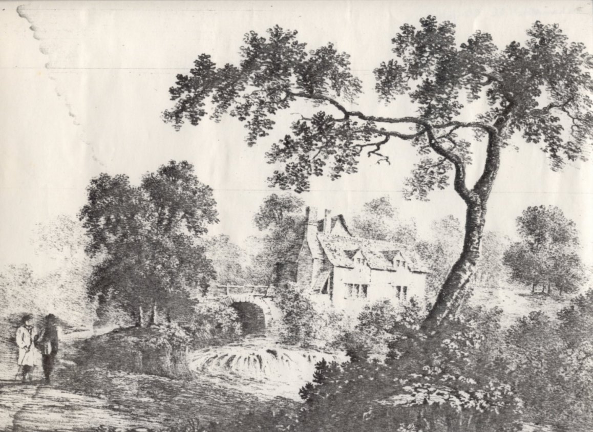
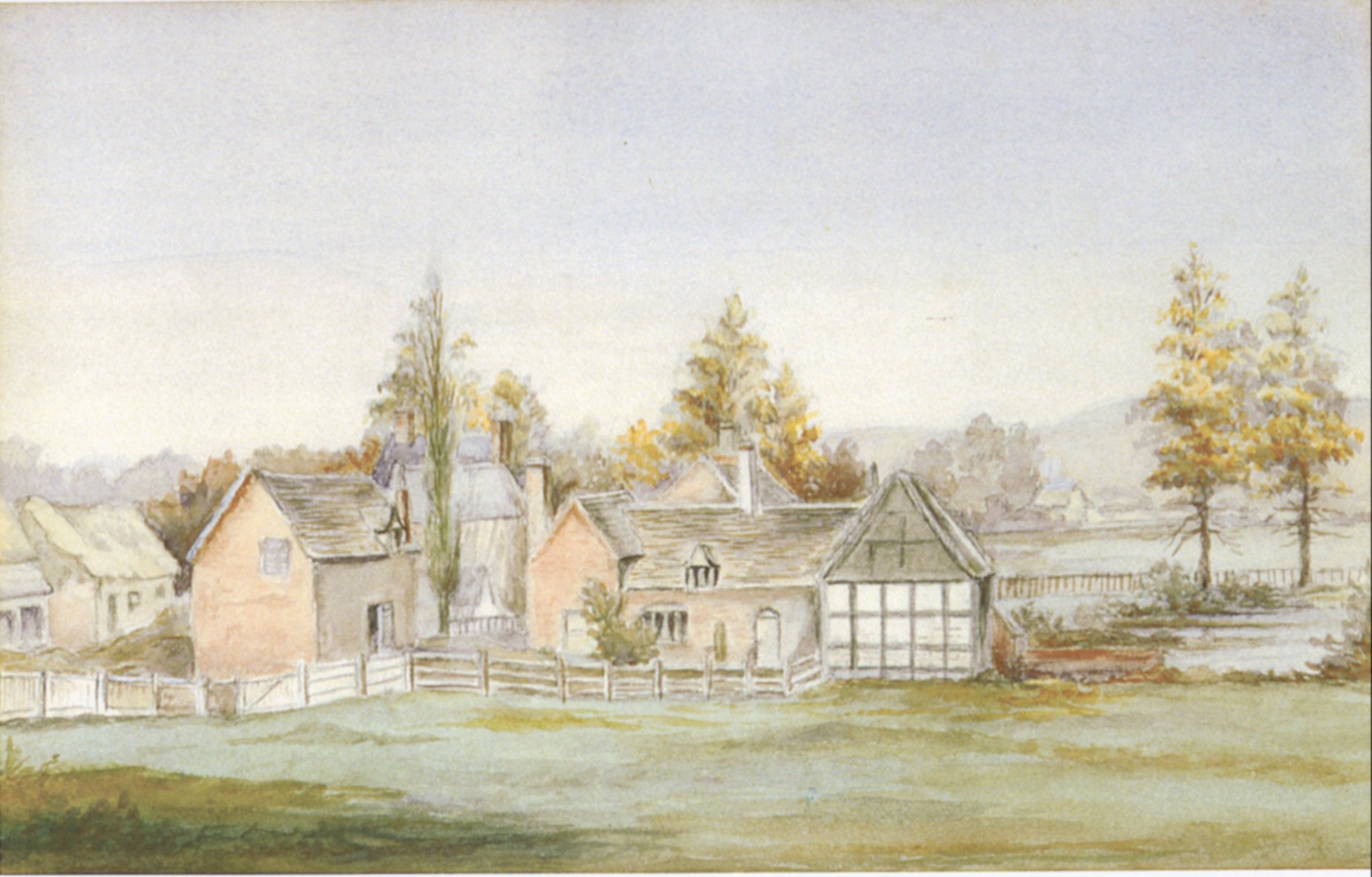 The watercolour painting of Sandford “Old farm &c. on Sandford Fields now known as the Murvagh Ground facing Christowe and Newick House.” “Copied by Miss Marklove 1897, from a sketch by Miss L Bingham, from window at Christowe, 1867.” This painting is the only known chance we get to view the heart of Sandford. The original watercolour painting at one time hung on the wall (1979) in the Old Cheltonians Office in Cheltenham College. It was drawn circa 1860 and depicts the settlement from the south. It shows a settlement with a bewildering number of houses and farm buildings, but if one studies the Merrett’s map of 1834, one can identify most of the buildings illustrated. The house in the foreground is Sandford cottage. It has what appear to be two wings of differing style. The east wing is possibly an attached timber-framed barn with a cesspool and pond by its side. The roofline of the farmhouse can be seen behind the cottage. To the west of the cottage and in the foreground are various outbuildings, at least one appearing to be thatched. The steep-roofed structure with tall chimneys in the background is ‘Gothic Cottage’, the short-lived successor to the Great House. In the distance beyond the cesspool is a building that does not appear on any town map. It may be artists' licence and may depict Bellevue Farm or even the Mill, or it could just depict a house across the fields on what is now London Road.
The Spa was built in 1802 by the proprietor Mr Barrett. The Spa was situated off College Road in Sandford Park. The spa was short lived, being replaced by Cambray Spa, and became a private residence called (in 1885) ‘Field Lodge'. The site was for many years occupied by the offices of the Parks Department. The present building and nearby public conveniences were erected in the 1960's after a fire destroyed most of the old premises.
The Sandford Estate or Great House was sold by auction on 2nd October 1811. The advertisement in the Cheltenham Chronicle and the sale particulars survive.
          1811 - Advertisement in the Cheltenham Chronicle.

              "To be sold at the Plough Hotel, Wed. 2nd day of October
               Desirable estate situate in the Town of Cheltenham, all
               That rural and delightful residence called Sandford Villa
               With coach-House, stables, barn, granary, mill-house,
               cidermill, garden, pleasure grounds, capital orcharding
               and meadow land adjoining; containing in the whole about
               ten acres, situated near the Chalybeate Spa and within
               five minutes walk of the town of Cheltenham.
               The house has been lately improved and fitted up at a
               great expense, and contains dining-room and drawing room
               with a bow window to each; a breakfast parlour, nine
               bedrooms, a water closet and a china closet; a servant's
               hall, kitchen, scullery, dairy, laundry, brew-house and
               various other convenient offices. Also a small detached
               Gothic cottage and garden lately erected at the extremity
               of the orchard."
The sale particulars give a more detailed description of the various lots for sale. The estate was lately in possession of a bankrupt, Theodore Gwinnett indicating that the Wood’s had disposed of the estate before 1811. Lot 2 is of interest in that it indicates that the Wood family still had an interest in the area.
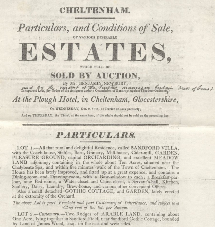 The person who drew up the above advertisement could not have realised that he was giving to posterity, probably for the only time in its history, a description of the house that within thirty years was to disappear without trace. The estate had belonged to the Dingley's in 1518. In the reign of Charles II the Wood family bought the estate and it remained in their hands until shortly before 1811. In 1803 Rudge in his history of Gloucestershire, records that James Wood Esq. of Gloucester owned Sandford which had been in the family for two or three centuries. Two points come from the sale particulars; the house had been renovated and therefore was not new and the farm and cottage were not included in the sale. Either the Wood family had decided to renovate the house themselves before selling or more likely the estate as a whole was sold previously and broken up, the house was renamed Sandford Villa and part of the land was used to build a new house called Gothic Cottage, later known as Murvagh, erected at the end of the orchard of which I will come to later. In the years to come the property would be divided further and the land sold for development. The present Sandford House situated on the corner of Old Bath Road and Avenells Parade was erected sometime before 1885.
The first mention of the name (Murvagh Lodge), is in 1842. The name ‘Murvagh’ probably originates from a village of the same name in Donegal, Ireland. Mrs Catherine Ball who lived there until 1860 occupies the property. Major Stock occupies the house from 1865 to 1870 and Mrs Stock occupies it in 1875.The name refers to the Italianate style house on the corner of Keynsham Road and Sandford Road. I believe the house to have been built in or just before 1811 on land once covered by a cherry orchard. The house is mentioned in the aforementioned auction particulars as Gothic Cottage. Although on maps there is no indication of any building until Merrett's map of 1834. By 1842 Gothic Cottage appears to be called 'Murvagh Lodge' (Cheltenham Annuaire). There is some scope for confusion here because one of the other buildings (Sandford Cottage) was also called Gothic Villa. In 1979 the house had a number of roofline angles giving the appearance of various alterations and additions. In the late 1980's Murvagh was sold by Councillor Aldridge and heavily renovated to the extent that only the outside walls remain of the original building.
The Cheltenham Water Works pumping station in Keynsham Road was built in the 1880’s. The site was used until the 1970's. The station was demolished in the 1990’s.
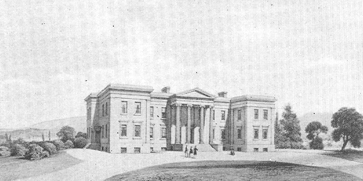
The General hospital was built on Sandford Fields in classical style in 1848, under the direction of Dr. David Hartley at a cost of Ł9000. It is apparent that the Hospital Board purchased part of the Sandford Fields in the 1830’s, a considerable time before they erected their new hospital. A Report of the Board that appeared in the Cheltenham Chronicle, 16th January 1834, pp.2-3, states that the land had been purchased and a boundary wall and extensive sewer were nearly finished and that they were concerned with the choosing of an architect for the intended hospital. The Report under expenditure, states the purchase of the land in Sandford from Mr. Wood of Gloucester was for Ł1270. By 1842, they still had not built the hospital and had received an offer for the land:- “Land in Sandford: Communications have been made to the Board (i.e. The Hospital), respecting the purchase of the land in Sandford Field; but, as the offer at half its value was rejected ….”. The Board conceive that the interests of the Hospital will be best served by retaining this property in its possession, especially when they consider, first, the increasing value of land in that neighbourhood, reasonably to be expected from the improvements in progress around it, and, secondly, that, even in its present condition, it is almost as productive as it would be if sold at such a price as has been proposed.”
The baths and Cottage were built in 1880 on land known as Sandford Dread, probably implying marshland, there once being springs nearby. A College Baths pumping system is discussed in more detail in the chapter dealing with the development of Murvagh Field.
To the east of the College Baths is the fire station, which was erected circa 1971 on land used since the 1880's as a nursery and allotments.
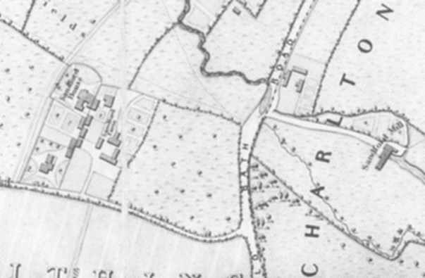
The dates cover the time when the Sandford estate was broken up and the area altered beyond all recognition. It is not easy to understand what was happening to the various parts of the property and who was making them happen. The various maps were a major source of information together with the Cheltenham Annuaires and directories that started to appear in the 1830's. There is some confusion over the names given to the various houses with Sandford House, Villa, Lodge & cottage; and Gothic Villa and Cottage. Merrett's map of 1834 shows the settlement in fine detail. There is Murvagh/Gothic Cottage and for the first time the estate’s outbuildings are depicted. Later maps show Sandford Terrace, together with a road (the southern extension of Keynsham Road), created out of a footpath. On Merrett's map a line cuts the great house in two, later to become the back lane to Sandford Terrace. It is unfortunately not possible to tell when this division took place. Did it occur in 1811 when the estate was divided up or at a later date?
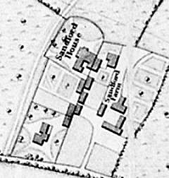 Merrett's Map of 1834, showing Sandford Manor in fine detail. Sir Francis Burdett MP for Westminster possessed Sandford, sometime between the years 1811-1828. I assume he was resident in the great house and possibly acquired it in 1811. Papworth the architect produced a design for drainage at Sandford Villa in 1824, for messrs Ingledew & Shearwood. The rating accounts inform us that the family in residence from at least 1828 was the Beans, the Cheltenham Annuaires give the Beans residence as either Sandford House/Villa or after 1844 as Gothic Villa (not to be confused with Gothic Cottage), and is addressed Sandford Fields. Except for a Mr Pell who occupies Sandford Villa (the names Sandford Villa and Gothic Villa are frequently interchanged), A perusal of the following extracts from the Cheltenham Annuaires and directories will show the problem:- In 1837 Sandford House, Sandford Fields is occupied by Major Bean; in 1839 Lieut-Col Nathaniel Bean lives there until 1842 in which year Mr Pell is occupier of Sandford Villa; 1843 Sandford villa is back in Lt-Col Bean's hands; Harper's directory 1844 Lt-Col Bean occupies Sandford, near Sandford Terrace; William Weaver lives in Gothic Villa while Thomas Arkell, Candle manufacturer has Jordan's Sandford Farm where he carries out his work; Thomas Arkell also has a vegetable shop in Bath Street; 1847 (Hunt & Co directory) Lt-Col Bean occupies Gothic Villa; 1850 he occupies Sandford Villa; 1851 he lives in Gothic Villa, Sandford Road, and also in Sandford Villa; 1856 Sandford has no occupant while Mrs Bean lives in Gothic Villa, Sandford Fields; 1858 T.L. Hinton lives in Gothic Villa while Sandford is still unoccupied; 1865 the last mention of Gothic Villa and T.L. Hinton; 1870 one directory under Sandford Villa is still unoccupied while in another there is Sandford Terrace in its place; 1872 Sandford Villa is still vacant; 1874 the last mention of Sandford Villa is made. There is a new Sandford House in Old Bath Road near the London Road junction. Tithe Award of 1850, shows Nathaniel Bean as owning 3 acres of land. Dramatic changes take place between 1835 and 1845, presumably under the auspices of the Beans'. Between 1835-42 the great house, latterly known as Sandford Villa, was demolished. The lower two thirds of Sandford Terrace with the back lane and also a small public house called "The Cricketers Arms" was erected. The Beans' appeared to have erected a new residence just to the east of the old house and I believe they called it Gothic Villa hence the Annuaires confusion over Sandford Villa and Gothic Villa as the home of the Beans'. There is a glimpse of Gothic Villa in the background of the 1860’s painting of Sandford. It shows a high-pitched roofline and it may have been built in a Gothic style. Mrs Bean left Sandford around 1856. Her husband, Lt. Col. Nathaniel Bean had died at his residence in Sandford in 1851. His obituary was placed in the Cheltenham Chronicle 15th December 1851. His wife died in 1870 aged 51 and was buried with her husband.1 He was buried in the old Parish Cemetery and a memorial to him was inscribed:-
        Here repose the remains of Colonel Nathaniel Bean, late
           of H.M. 17th Regt (For many years resident of this
           place), who died December 13th, 1851, aged 76. Also of
           Martha, relict of the above, who died Jany 31st, 1870,
           aged 81 years.
A tablet to him is to be found in Holy Trinity in Cheltenham and is inscribed:
graduate of Clare Hall, Cambridge and late of H.M. 17th Regiment of Infantry after a residence of 33 years in this Parish (the greater part of which time he was a member of this congregation). He died on the 13th December 1851 in the 76th year of his age "To him to live was Christ". A terrier of the property owned by Pate's Charity was drawn up in the late 1840's. Amongst of properties listed was Sandford Lodge. (Goding p406). In 1858 a Mr T.L. Hinton occupies Gothic Villa. From 1858 until 1872 Sandford Villa (e.g. Gothic Villa as referred to in Harper's directory of 1884), appears to be unoccupied. Coupled with the partly industrialised farmstead the old settlement must have presented a somewhat rundown appearance. Subsequent to 1872 Gothic Villa shows on Bacon's map of 1890, sandwiched between two short lived roads and is no longer there on his map of 1905. According to the maps, two roads were driven through the settlement from Sandford Road to College Baths Road between the years 1860-1880. One was along the line of the old approach to Sandford Farm, while the other ran just east of the old Farm House. In 1884 Cheltenham College bought the eastern half of the later Murvagh Field as a junior playground. In 1893 they bought the western half that included the farmstead. The old farmhouse and surrounding buildings were demolished and in 1896 the two halves of Murvagh Field were levelled.
13th century - Thos Godmo--- of Sandforde. 1292 - Hugh of Sandford, deacon, Jno of Northfield, priest, Thos of Sanford, priest. 1518 - Recorded by Robert Atkins in 1712 as having a Manor in possession of Thomas and Phillipa Dingley 1803 - Rudge in his History of Gloucestershire records that James Wood Esq. of Gloucester owned Sandford which had been in the family for two or three centuries. 1811-28 - Became a residence of Sir Francis Burdett, M.P. for Westminster. (Cheltenham College Register (1928) records this and that Sandford was once the property of a Gloucester Banker named Wood, whose great-grandfather-father bought it in the reign of Charles II. 1834 - Merrett's map shows Murvagh (then called Gothic Cottage), Sandford Farm, Sandford House and another building to the east (Sandford Cottage and barn). 1835-40 - From this time the Cheltenham Annuaires and Directories become a chief source of information. Many changes take place. 1837 - Major Bean occupies Sandford House. 1840-42 - Two-thirds of Sandford Terrace is built and a back lane appears, originating from a property division. 1842 - Mr Pell occupies Sandford Villa. The first mention occurs of the name ‘Murvagh’ - Cheltenham Annuaire. 1843 - Lt-Col Bean lives at Sandford Villa. (Cheltenham Annuaire) 1844 - Thomas Arkell occupies 'Jordan's Sandford Farm' (Hunt & Co directory). 1847 - Lt-Col Bean occupies 'Gothic Villa' (Hunt & Co Directory). 1850 - Lt-Col Bean occupies 'Sandford Villa'. 1851 - Lt-Col Bean dies at the house. His wife died in 1870 after having left Sandford. 1856 - Mrs Bean lives in 'Gothic Villa', Sandford Fields. 1856-72 - Sandford appears to be unoccupied. 1858 - Mr T.L. Hinton is living in 'Gothic Villa'. 1865 - Neither Mr Hinton nor 'Gothic Villa' is mentioned. 1860-80 - Two roads were driven through the settlement from Sandford Road to College Baths Road. One had ceased to exist by 1900, the other before 1920. 1884 - The eastern half of Murvagh Field was bought by Cheltenham College as a junior playground. 1893 - The western half of the field was purchased. 1894 - The Cheltenham College Register of 1928 records that in 1894 "Two ancient houses in Murvagh Field, one of which was Sandford Farm, were demolished." 1896 - The field was levelled. 1947 - The field was "converted into an athletics field, an exactly level oval track being laid." (College Register, 1951)
By 1928 the name Murvagh had attached itself to the College's junior playing field. In 1947 the field was converted into an athletics field, an exactly level oval cinder running track being laid. There was a pavilion situated half way up the field against the western boundary wall. Around the parameter there were old lime trees and railings with double entrances at the southwest and northwest corners. In 1979 the Cheltenham College sold Murvagh Field to Bovis for housing development with permission to build 55 houses.
This section owes its existence to my father Bernard Rawes, who helped compile this history by concentrating on the people who lived at Sandford. A settlement is made up of people. Over the centuries that Sandford existed, hundreds of people must have been involved in its upkeep whether owners or tenants or folk living in nearby Cheltenham. The mill workers, the builders, the agricultural labourers, all had a part to play. The following section attempts to deal with a small fraction of those folk and families who were recorded as either living at or being involved with Sandford. An extract found in a deposit book possibly dated from the second half of the 13th century (GRO D 1876) mentions possibly the first Sandford inhabitant to leave his name to posterity: "Thos Godmo --- of Sandforde. The Hockaday abstracts (147 Cheltenham to 1647), mentions:
1292. 8 June  Hugh of Sandford      ord. deacon (see Worc. dioc.)
              Jno  of Northfield    ord  priest
              Thos of Sanford       ord  priest
 Francis Burdett MP As mentioned beforehand, Sir Francis Burdett, Bart., MP for Westminster possessed Sandford sometime between the years 1811-1828. He was descended from a Derbyshire family, born in 1770 to Francis Burdett and Eleanor daughter of William Jones, of Ramsbury in Wiltshire. Sir Francis was M.P. successively for Boroughbridge, Westminster, and North Wilts. He married in 1793 Sophia, daughter of Thomas Coutts, a wealthy London banker. Sophia's mother was Harriet Mellon a Cheltenham girl who ‘made good’ as an actress. There is a biography about Harriet called 'Memoirs of the Duchess of St.Albans' by Mrs C.B. Wilson. 'Goding' (p392) states that Sir Francis came to Cheltenham in May 1805. He was in a very poor state of health and was cured within a few days, presumably from the 'taking of the waters', no doubt adding to Cheltenham's popularity. Sir Francis eventually died in 1844 and was buried in Ramsbury Church in Wiltshire, the home of his mother's family. An article in 'Country Life' (8th March 1956), throws light upon one of his daughters. A portrait painting had been acquired at an auction in Harrogate. The new owner (Mr H Banks Fearnley), had entered a photograph of the painting along with a request for information on the paintings subject. The request was followed by an answering article from the Editor here reproduced: "The portrait is probably that of Baroness Burdett-Coutts (1814-1906), youngest daughter of Sir Francis Burdett and heiress to the great fortune of her maternal grandfather, Thomas Coutts, the banker. There is a resemblance in features and figure to other known portraits of her, which show her to have been tall and slender, with a long thin face and an unsmiling but kindly expression. She habitually dressed her hair in the manner shown in the portrait. Angela Georgina Burdett, who assumed the additional surname of Coutts on coming into her fortune in 1837, devoted her life to philanthropic works, and for her services to the nation she was in 1871 created a peeress in her own right. The portrait, the date of which can probably be placed at about 1850, is well painted and reveals the essential character of this great Victorian figure. From among the numerous possible painters it is impossible to make any reliable suggestion."
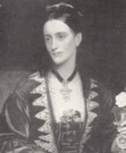 Angela Burdett-Coutts See Burke’s Peerage, 1896, for further information on the Burdett family.
                              Mellon =1 Sarah  =2 Thomas Entwisle
                                     | Mr & Mrs Entwisle kept
                                     | of Town's Post Office,
                                     | She died in 1815 aged 63.
                                     | Thomas died in 1819 aged 55.
                                     |
                                     |
                    =1 Thomas  =2 Harriet
                    |  Coutts     she married at St.Pancras,
                    |             Middlx. March 1815.
                    |             (Actress, see Goding's H of
                    |             Ch p 354.) Duchess of St.Albans
                    |
                 Sophia  = Sir Francis
      died in 1844 and   | Burdett, Bart. of Foremark,
      buried the same    | Co. Derby. MP for Westminster
      day as her husband | died 31 January 1844
                         |
   ------------------------------------------------------
   |           |       |         |         |            |
  Robert     Sophia  Susannah  Joanna  Clara-Marie  Angela Georgina
  6th Baronet                                       Frances Baroness
  Burdett                                           Burdett-Coutts
                                                    1814-1906
                                                    heiress to Thomas
                                                    Coutts.
Sarah and Thomas are buried in St. Mary’s Churchyard. The following is recorded on a Memorial Inscription once in the Cheltenham Parish Church:-
“528.A: Sarah Entwisle Ae 63 1815. Thomas Entwisle Ae 55 1819. This tablet was erected to the memory of Mrs Sarah Entwisle wife of Mr Thomas Entwisle by her affectionate daughter Harriot (neé Mellon), Duchess of St.Albans, September 21st 1832.y”
In Norden's Survey of 1617, John Currier holds house in Sandford. The pedigree below has been constructed from the Charlton Kings registers.
                           John = Eliz
                        Currier | buried CK 1628
                     of Sandford|
                        d 1629? |
                                |
      ------------------------------------------------
      |            |                  |              |
     John        William            Walter         Edmund
     b 1591      = 1626             b 1595         1598-1606
                 | Ruth Gale        = Anne Pate
                 |
           ---------------------------------------------
           |         |           |           |         |
         Robert    John       Frances       Mary      Eliz
         b 1628    b 1626    b 1629         b 1631   b 1634
The Higgs of Cheltenham are very numerous; therefore only references alluding to those specifically connected to Sandford have been included. It appears that the family lived at Sandford from at least the middle of the sixteenth century. Apart from owning the land upon which Holy Apostles was built, they are stated as being the owners of the Mill property in the 1860's. I believe their residence to have been Bellevue Farm. This belief is supported by the Deeds to the property. Some of the following pedigree has been gleamed from 'The Higges Family by William Miller Higgs, 1933.
                                     John  = Cheltenham 31 Jan 1563
                                   Higges  | Elizabeth Machyn or Machen
                              of Sandford  |
                                           |
        ------------------------------------------------------------------
        |           |           |              |           |             |
     Thomas      Walter      Anthony         Edith       Susan        Margaret
   of Alston    1566-1573   of Cheltenham    b 1565      b 1573       b 1576
   b 1565                   1571-1626
                            =
                            |
                            |
                    -----------------------------------------------
                    |                             |               |
                 Thomas = Margaret              Walter         Samuel
                 d 1647 |                       1609-1698      1622-1719
                (Admin.)|
                        |
                 -----------------------------------------
                 |                  |                    |
              Thomas = Eleanor    John                 Anthony
         of Sandford | d 1721     b 1629               b 1645
         d 1679 Will | Will
                     |
                   --------------------------------------------------------------
                   |              |               |           |        |        |
                 Thomas          John          Robert      William    Walter   five
            of Sandford          of Westall    of          of                  dau's
            b 1660               = Mary        Gloucester  Sandford
            d 1727 Will            Brown                   1676-1710
            =
            |
            |
            |
    -----------------------------------------------------------------------
    |         |          |           |              |          |          |
Sarah       Samuel    Thomas       John          Margaret     Mary     Elizabeth
c1688-1745  d 1720    Bc1691-1758  of Sandford   = -------    = -----  = -------
Will        Will       =           d 1747 Will     Woodcock     Smith    Hawthorne
            =
            |
            |
            ----------
                     |
                   Samuel        = Catherine dau of Edmund Harris
                   Yeoman d 1759 | of Gloucester, Attorney (see
                   Will          | Visitations 1682-3.
                                 |
              -----------------------------------------
              |                      |                |
           Charles                 Thomas           Harris
           of Alcester, Co.Warks   of Cheltenham    of The Leigh
           bc 1718 = Susanna
            d 1781 | Cook
                   |
   ---------------------------------------------------------------------
   |                |                  |                |              |
  Jane            Charles           Elizabeth         Samuel       Susannah
  = Giles         of Prestbury      = Rev Wm.         of Charlton  = John
    Greenway      = Rupertia Collier  Pickering-Reid  Kings          Gale of
    of Gloucester   of Blockley       of Winterbourne                Charlton
                    Widow of Rev      Dorset                         Kings
                    Henry Brown
Men and Armour 1608: At Sandford: Anthony Higgs husbandman, tall and aged about 40. Thomas Higgs holds as above a messuage or tenement with a garden and three closes of meadow or pasture called by the name of Sturmies field, Sturmies Orchard and the leyes containing by estimation 34 acres. (Norden's survey 1617 p349 under Naunton) William Higgs holds as above and certain land in Charlton Kings, Norton, Westall & Sandford formerly belonging to Henry Compton Knight and Giles Greville - a mansion house with a garden and orchard and an adjoining close - 2 rods other closes etc. (See Barbara Rawes' notes). Thomas Higgs late of Sandford - letters of Administration granted 1647 to Margaret his relict (Hockaday Abstracts Cheltenham 147). Thomas Higgs, of Sandford was buried 21 March 1679. (Tomb, St.Mary's, PC Cheltenham) Cheltenham Manor Books (c1697 p275): "It is ordered that upon the 1st of May that Homagers ........ at the house of Eleanor Higgs ---- in Sandford by ... of the clock in the morning and ..... repairs to a certain close of the said Eleanor Higgs called the Hopyard in Sandford aforesaid ........... Eleanor to close a wall for a footway and a driveway for her ...... and carriages. Samuel Higgs died 1720 his possessions to his brother Thomas Higgs. Thomas Higgs, of Sandford had Sarah died 27 Nov. 1745 aged 57. & Thomas died 16 Nov. 1758 aged 67. He died 4 Aug.1727 aged 67. (St. Mary's burial)
Wills:
Zackary Ireland, of Sandford, wever, shortish & in his 20's. (Men & Armour), Margaret Ireland holds house in Sandford (Nordens survey 1617), Edward Ireland late of Sandford (Will 1769), Hester Ireland of Sandford (Will 1730), Edward Ireland, Yeoman late of Sandford (Will 1769). The Ireland family were resident in Sandford for a considerable time. I deem it likely that their residence was Sandford Farm. The information below has been gathered mostly from Wills and memorials once in St. Mary's churchyard in Cheltenham..
                                  Ralph = Margaret
                                Ireland | of Sandford
                                 Wever  | Will
                                Will    |
                                        |
                           --------------------------
                           |                        |
                        Zackary                    John
                        shortish and
                        aged about 20
                        in 1608.
                        Charles = Hester
                        Ireland | of Sandford
           Sadler of Cheltenham | d 1780 Will
                    d 1686 Will |
              --------------------------------------------------
              |                         |                      |
            John =                    Sarah                 Hester
                 |                    = James
                 |                    |  Wood
                 |                    |
         --------------------         -------------
         |                  |         |           |
      Charles             Henry    William      James
                                Anthony = Susanna
                                Ireland |
                     Yeoman of Sandford |
                            d 1722 Will |
             -----------------------------------------------------
             |                 |          |           |          |
           John             Anthony     Susanna    Elizabeth    Mary
           d 1686                       d 1682
           = Sarah
           | d 1723
      ----------------------------
      |                          |
   Thomas                      John
   d 1710
   an infant
Edward = Mary
Ireland |
|
|
Edward = Jane
Yeoman of Sandford
d 1769 Will
In Men and Armour 1608, Henry Lane, (shortish and aged about 20 in 1608), yeoman and Walter Lane (tall and aged about 20 in 1608), servant are mentioned as living at Sandford. In the Charlton Kings registers Henry married on 11th July 1588 Edie Higges. On a tombstone in St.Mary's Churchyard, Cheltenham there is recorded:- Henry Lane of Sandford, was buried 9 April 1632, Richard Lane, glover, was buried 13 Oct. 1646, Marjory, wife of Walter Lane buried 31 Jan. 1646 (Was Walter the same as the Walter in 'Men & Armour'?).
Thomas Lynet held Sandford Mill and land in Cheltenham Hundred and at Kings Stanley. On 29th May 1547 Elizabeth daughter of Thomas Lynnet married William Pate at Charlton Kings, and Sandford Mill came into the tenure of Richard Pate, gentleman ....... (born 1516). Extract from the Will (1551) of Thomas Lynet, gentleman of Charlton Kings Will: "It[e]m to Elizab[eth] my dogt[er] the myll at Sanford to enter immediately aft[er] the decease of Alys my wyfe."
                John Pate
                   |
                   |
                Walter  =                     Thomas  = Alice
                Pate of |                    Lynet of | will dated 1551
             Cheltenham |                    Sandford |
                        |                    Mill     |
             -----------------------                  |
             |                     |                  |
        Richard born 1516                          William = 1547 Elizabeth
        M.P. for Gloucester                      will 1597 |
        Founder of Pate's                                  |
        Grammar School                                     |
        Died 1588                                          |
                                                           |
                                                        Richard  = 1617 Edith
                                          of Charlton Kings      |
                                        (held Sandford Mill)     |
                                                    d 1650       |
                                                                 |
                                                                 |
        --------------------------------------------------------------
        |                     |             |           |            |
      Lynnet                Alice         Anne         dau          dau
      Gent of CK.           B 1614 CK     = Walter     = - - -      = - - - -
      d 1685 Will           =1637 CK        Currier      Higgs        Blick
      1= Mary                John Stubbs
      2= (1681) Katherine    Clerk
         Trotman b 1657      b 1610
In October 1599 four men were appointed to view le mill meare leading from the le fludgates of Richard Pates, gentleman to a certain way leading from Cheltenham to Charlton by the furlong called Mill Furlong (Chelt. Manor Court book GRO D855 My p151). Richard Pate still held Sandford Mill in 1617.
The Pates' also owned the Cambray or Cheltenham Mill.
Through 'Men & Armour' one sees another view of Sandford in microcosm. It is most fortunate that a separate section was allocated to 'Sanford'. Anthony Higgs, presumably of Bellevue Farm but possibly not as the owner; Zackary Ireland, either of Sandford Farm or a tenant in the Great House; The 'Lanes' are represented by Walter, & Henry, which leaves William Wayte (tall aged about 20), Thomas Greeninge (tall aged about forty), John Powell (an apparent trained soldier), mentioned in Nordens Survey of 1617. Robert Mylton ( of middle height aged about 40). Being a Milner we can place William Wayte in the Mill, with Walter Lane as his assistant (a better and probably more accurate description). Thomas Greeninge (see below) & Robert Mylton are unplaced. As the work of Barbara Rawes on Cheltenham has shown, it should not be assumed that every able-bodied man is included. There are many reasons why people would did not wish to place themselves ready for military service. Plus of course there would have been men who were not able-bodied who were not mentioned because of either age or ill health. Therefore the nine men below would mostly likely be the cream on top of a large milk churn of humanity.
William Wayte milner 1,p.
Walter Lane servant to
William Wayte 1,p
Thomas Greeninge husbandman 2,p
Henry Lane yeoman 1,ca
John Powell yeoman tr
Zackery Ireland wever 1,ca
Anthony Higgs husbandman 2,p
Robert Mylton husbandman 2,m
Legend:
1 = aged about twenty: 2 = aged about forty: p = of tallest stature:
m = of middle stature: ca = of shorter stature: tr = trained soldier.
Thomas = Ann
Greening |
Sheep farmer |
of Sandford |
d 1639 Will |
---------------------------------------
| | | |
Nathaniel Thomas Elizabeth Mary
=
|
|
Samuel
=
|
|
Abigail
Extract from Cheltenham Parish Register:-
Map shows Hatherley Court & Hatherley Road only. Nathaniel Bean owns 3 acres of land occupied by Charles Holliday. In the 1841 Census, Mr. Holliday was described as a Butcher, aged 25. Charles Cooke Higgs owns 5.1.10 acres of land & Mill House, occupied by John Greening. Dame Jane Eliza Prinn owns 127 acres of land occupied by William Jordan. Samuel Page owns 3 acres of brickyard & land (This appears to be all in Sandford area by relating to names).
Mr Bastin jr of Sandford, has been summoned by our High Bailiff, & fined in the penalty of 43s? for law breaking & a warrant made out against James Butt alias Pool, for assorting the above gentleman in the execution of his official duties. John Bastin wrote a letter denying breaking lamps in next issue of the Chronicle. Mr Bastin owned a cornfield in Sandford & found 2 stray horses (Chronicle 29 Sept. 1814)
Mention 11 April 1692 Richard Milton came to the Court to sell to Fr Still arable land in the field - - - to Sandford.
|
|
on Murvagh Field, Sandford 1979
Carried out
by
Julian Rawes
|
|
In 1979, the Cheltenham College running track, otherwise called Murvagh Field, was scheduled for redevelopment. The field is set within the confines of Old Bath Road, Sandford Road & College Baths Road (fig 1).
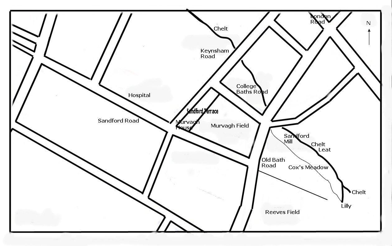 Fig 1: The site of Murvagh Field in the Sandford Area, Cheltenham. The ‘field’, along with the land occupied by Sandford terrace and Murvagh house, was once part of an ancient country estate known as Sandford. The settlement was swept away and forgotten during the 19th century. Sandford house was demolished in the 1830’s to be replaced by a ‘Gothic Villa’, which was itself pulled down in the 1880’s. (1). The farm, along with a cottage and outbuildings, was demolished after the Cheltenham Boys College purchased the land in 1894. The map of Cheltenham published by H S Merrett in 1834 was the first to illustrate Sandford in fine detail. The map details the Manor house in the north west corner divided by a property line which remained long after the house was demolished to become the present access lane for Sandford Terrace. The newly built Gothic Villa to the north east, Sandford Farm and cottage, along with a number of outbuildings, and it also depicts the present ‘Murvagh’ House, bordering Sandford Road and built in 1810/1.
 The site of Sandford House, Sandford Farm and Murvagh in the Sandford Area, Cheltenham. The painting depicted below, is the settlement viewed from the south with Sandford Cottage in front of Sandford Farm on the right, farm buildings to the left and the tall chimneys of the 1830’s Gothic Villa set behind. The cellar revealed in one of the service trenches belongs to the farm building to the left of the poplar.
“Old farm &c. on Sandford Fields now known as the Murvagh Ground facing Christowe and Newick House.” “Copied by Miss Marklove 1897, from a sketch by Miss L Bingham, from window at Christowe, 1867.” There is an article on Gloucestershire's moated sites written by Arthur Cardew(2). He is the first and only writer that I know of to mention the possibility that there was once a moated site at Sandford. He writes: -
Sandford would have been a very likely candidate to have a moat for drainage if not for defence. There is close proximity to water as the settlement lies near the river. The site may well have been periodically subjected to flooding as was nearby Cox's meadow. Observations during development on the eastern half of the site, despite many service trenches, failed to show any evidence of a moat. If there was a moat then the most likely position would have been around the old manor house. The "old resident" remembered the moats existence some sixty years before 1898, this would take us back to the 1830's just before the old house was demolished. The detailed Merrett’s map of 1834(3) however, gives no indication of a moat. Unfortunately the development of the area around the site of the house was not inspected so the question remains unresolved Below is Fig 1a, this indicates the course of the new approach road. It is fortunate that the site of Sandford Farm and Cottage remains mostly undisturbed under the central green of the new housing estate. A more detailed history of Sandford will appear in the Cheltenham Local History Society journal.
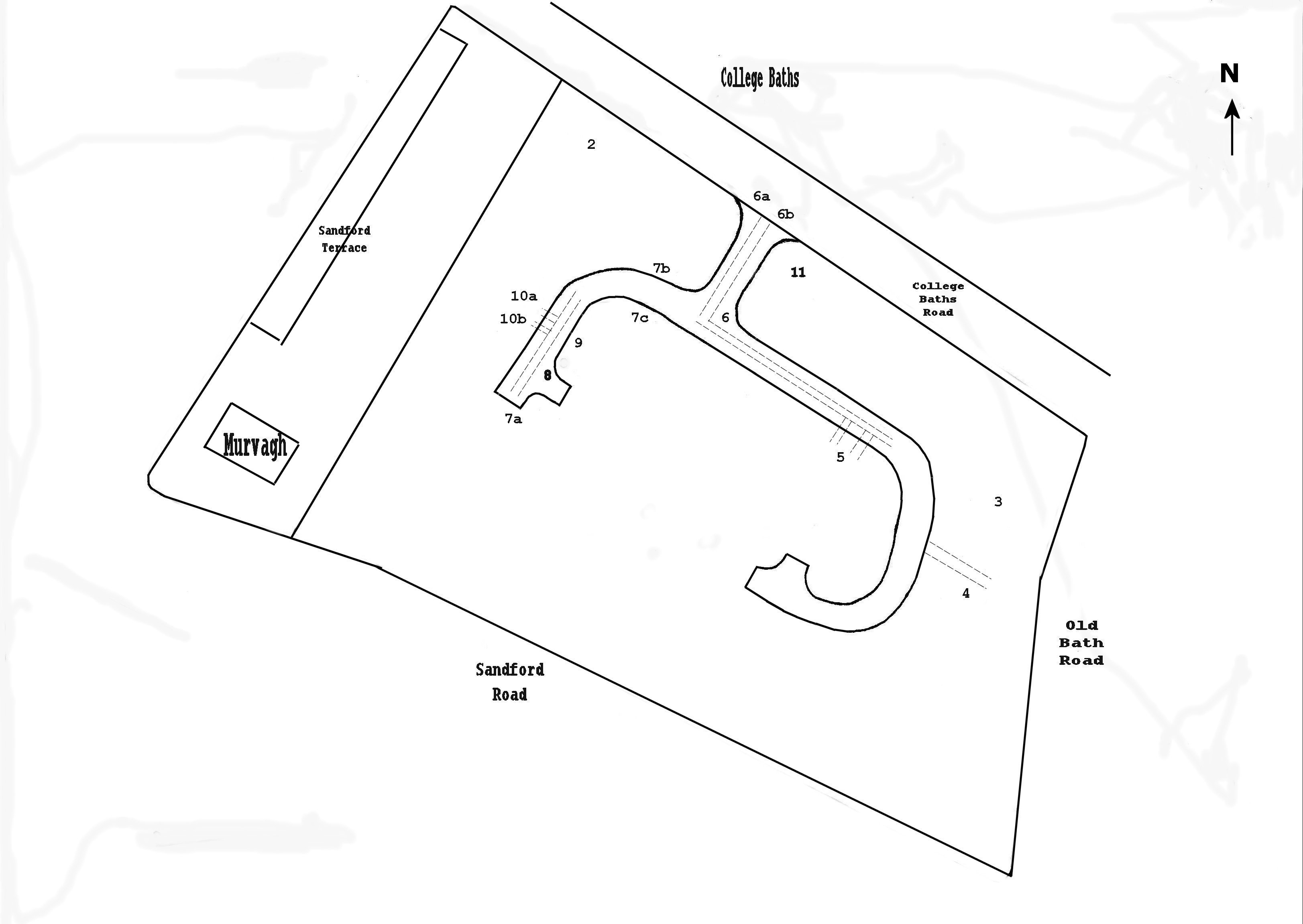 Fig 1a: Murvagh Field indicating the course of the then new road and the areas of note in the article The area known as Murvagh field, had, since the early years of the twentieth century, been used as a sports ground for the Cheltenham Boys College. Circa 1947/8, the southern half of the field had been lowered, while the northern half raised and the whole levelled prior to the laying down of a cinder running track. The task that I set myself, once I realised that a settlement had stood here, was to locate any of the old buildings and also to try and find proof of the rumoured moat.
The original lie of the land was of a fairly gentle slope from the south and to the east, down towards the Chelt. The slope is or was more pronounced in the southwestern quarter. The levelling process for the athletics track resulted in the loss of a 9 to 18m wide strip along the southern boundary, narrowing towards the east, of topsoil and underlying blue Lias clay. The material had then been spread across the rest of the field. The farmstead was demolished in 1894, buried under its own debris and covered by a layer of silty soil and was then covered by a layer of blue Lias clay. On the northern boundary and bordering College Baths Road is a bank that runs the full length of the field. It is assumed that this was created in or around 1900 as it supports (1979) mature lime trees. A road and a number of access drives now cut through this bank.
A large area to the south revealed nothing due to the substantial lowering of the ground. In the eastern half of the field, despite topsoil clearance and intensive trenching for house foundations, service trenches and the eastern branch of the new road, the area revealed little of archaeological significance. Sections cut for the new road showed a general and relatively clean silty deposit. An east-west aligned section of the new road revealed a series of faint but regular north-south aligned impressions in the natural. The impressions were in line with narrow ridge and furrow. Nineteenth century maps indicated that the eastern half had been an orchard.
Archaeological material was intense in the north western and central area. Unfortunately the trenching in the extreme north western corner was completed and concrete laid before it was realised that the trenches had cut through the foundations of Sandford House, therefore virtually no information about it was obtained. Topsoil clearance only revealed masses of rubble that probably came from its 1830’s successor, Gothic Villa. In the western half, from approximately half way down the field, there was an increasing depth of superficial deposit until near College Baths Road. On the western half, the following sequence in a vertical section was observed, approximately 35cm topsoil, 40cm sand, 25cm silt, 15cm gravel, 6cm silt.
In 1979, a large amount of topsoil, debris and natural underlying sand and clay was removed from Murvagh, and placed on the western and southern half of lower Reeves field in Charlton Park, where the topsoil had been scraped aside to be later replaced over the debris. Owing to this, there is now a pronounced drop between Lower Reeve’s Field and Cox’s meadow.
Foundation trenches about 4.50m from the edge of College Baths Road revealed part of a long disused water pumping system installed to supply the College Baths. The Baths were built in the 1880’s. The section of the system exposed was of a large circular brick construction 2.13m high by 1.52 across, with inlet and outlet pipes entering at either side, just above two decorative cast-iron circular cylinders standing about 120cm high by 38cm in circumference (fig 11). A metre or two to the west was a square brick shaft capped by a metal manhole cover with a tunnel connecting with the circular construction. An extension to this system was revealed further into the field under the southern edge of the new access road and nearer to a probable pumping house that existed on the site in the early 20th century. The assumed pumping house was erected further into the field alongside a short road that was cut through the site in the 1880s'. House foundation trenches sliced through the area where this pumping house had been, and exposed rubble trenches sitting on a 90 to 120cm-deep silty soil in which a boars tusk was found. The pumping house and system appear to have been abandoned by about 1920. From observations on the ground, a parallel system appears to exist in the grounds of the College baths, approximately 3m from the edge of College Baths Road.
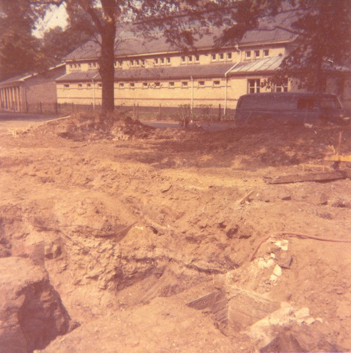 Photograph showing the Square shaft in the foreground with College Bath Road and the Victorian bathhouse beyond.
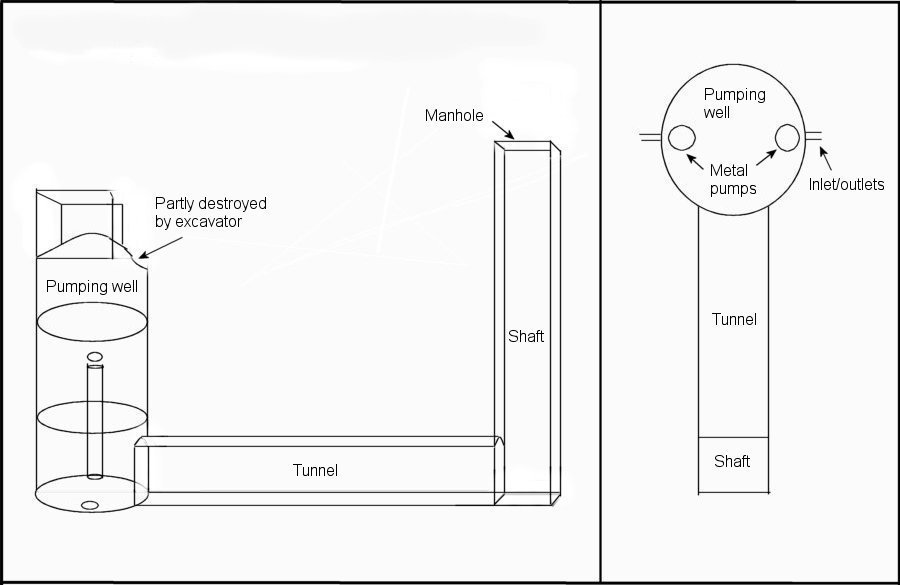 Fig 11: The pumping system for the College Baths.
Two cross sections were recorded, in trenches of a house foundation alongside College Baths Road (14m to the north) and opposite the entrance to the Fire station depot and numbered 2 on Fig: 1a:-
A service trench aligned east-west and to the east of Old Bath Road, numbered 4 on Fig: 1a, revealed a v-shaped ditch aligned north south positioned 6.1m from Old Bath Road. The ditch was filled with a mostly clean yellow silty sand deposit. Another thick layer of the same silty sand also covered the ditch, above which were vestiges of the cinder running track. No datable material was discovered. A feature was observed in a service trench leading from the main southern service trench in the eastern extension of the new road, numbered 5 on the plan. The feature that appeared to be a ditch, was aligned east west and was 122cm deep. The full width of the ditch could not be ascertained, but a width of 122cm was recorded from its northern edge to its deepest part. The feature did not appear in a similar service trench some 4.57m to the west.
Fig: 6a & b: (not reproduced): joining on to College Baths Road, the approach road was created to serve the new housing estate, see fig: 1a. The excavators firstly cleared up to 76cm of sub-soil and secondly dug two 1.83m-deep service trenches. The natural was generally revealed at about 100cm. However, 6.1m in from College Baths Road, the two service trenches revealed the natural sloping down sharply towards the north, both under the bank and College Baths Road and parallel to them. The two sections, show an overlay of soil, 91.50cm of clay, sand and grit, then 30.5cm of brick and rubble above silt and grit. The natural disappeared below the 1.85m line. It is not clear what this substantial feature is but could have been dug in the nineteenth century to protect the settlement from seasonal flooding of the Chelt. Papworth the Architect produced a design for drainage at ‘Sandford Villa’ in 1824(4), or does this feature in some way relate to a moat?
Fig 7: (not reproduced) - Topsoil clearance and trenching revealed a mass of re-deposited clay, brick, rubble and silt. On the new road's western arm was recorded two sections on either side of the new road just before it turned south. The sections revealed approximately 30cm of topsoil over a vertical dividing line between a rubbish, silt, brick deposit and probably re-deposited clay. This phenomenon appeared on either side of the road up to 76cm in depth although mysteriously the divisions were reversed. These features did not appear in the service trenches in the centre of the road. The road's southward journey took it through the heart of the old settlement and the machines exposed, under a layer of clay, heavy concentrations of cinders, rubble, rubbish, brick and large Cotswold stone blocks. Some of the stone blocks, along with others found on the surface nearby, were carved into ornamental shapes, one coming from a balustrade. When about 61cm of this debris had been removed, the insubstantial corner-footings of a building was exposed (fig.8). This was in-situ and fitted in with what the Merrett’s map depicts as the south-western corner of Sandford Farm. There was a single row of four bricks encircling two sides of a flag stone. The brick size was 10.16 x 22.86 x 6.35cm. See Fig: 8.
In the centre of the new road, the builders cut a 30.50m service trench between two inspection chambers. One was sited on the corner of the approach road as it turned to the south and the other at the road’s southern end. The section revealed a 1.67m deep by 14m-long depression. It is not clear what this depression was as it appeared to be set between the farmhouse and its outbuildings.
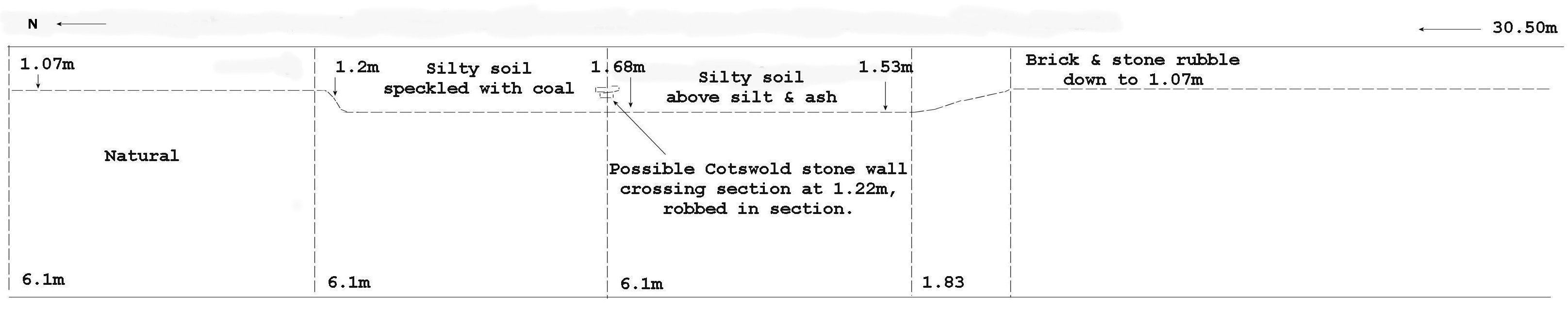 Fig 10: long north south section revealed in service trench. Some way into the depression a side trench over 3.04m long was cut to the west, which ended in another inspection chamber Fig: 10a&b. A section revealed that, from the base of the new road, after 22.86cm of topsoil there was 15.24cm of clay thickening to the west; 7.62cm of ash & cinder followed by silt. Natural was at 1.52m sloping eastwards to 1.67m. At 3.04m into the side trench nestling in the natural at 1.53m was a clean vertically sided trench approximately 45.72cm wide by 22.86cm deep and aligned north south. The trench contained stone blocks overlaid with bricks 30.48cm in breadth rising to about 12.70cm above the natural. This wall feature was revealed again approximately 1.52m away in another side trench.
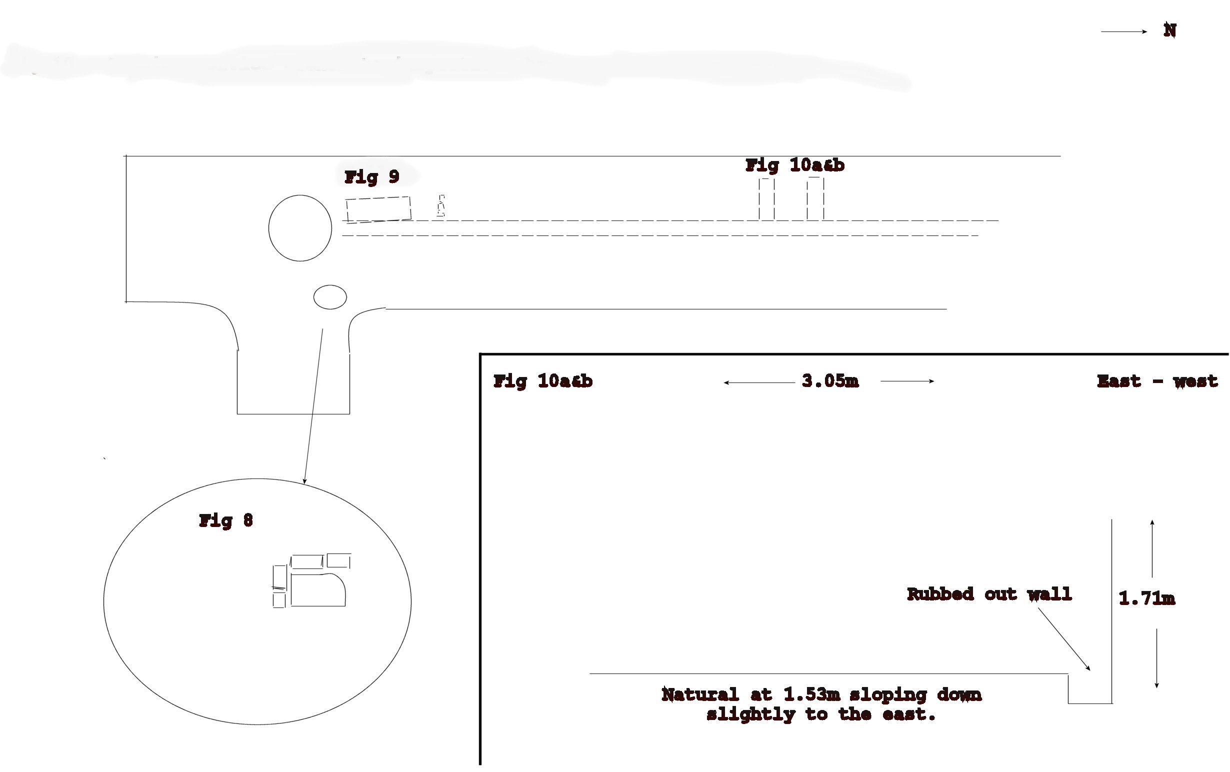 Fig 10: Showing position of service trench, inspection chamber and side trenches (10a&b). The clay overlay on this part of the site presumably came from further up the field when it was levelled. The thin layer of cinders observed, are in place for an old track that ran through the settlement later to become one of the two short north-south roads that existed at the turn of the 19th century. Another and similar cross-section was cut some 21.33m southward. As it crossed the depression the cinder layer sank into it and sloped down towards the west. The western side of the trench struck foundations of one of the outbuildings (fig.9) indicating that it had possessed a cellar. The machines hit the cellar’s eastern wall at 76.20cm from the building’s north east corner and sheered away the rest. The cellar was filled with bricks (size 10.97cm by 5.71cm), rubble, grey slate, stone blocks & blue-white wall plaster, the walls were 35.56cm thick. The building is depicted on Merrett's map.
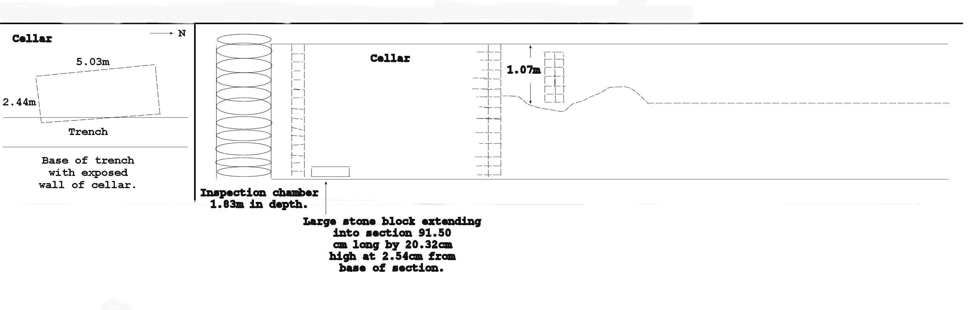 Fig 9: Inspection chamber, cellar and wall exposed in the western section of the service trench. Also indicated in Fig: 9, was what appeared to be the foundations of a stone wall set in a depression of the natural. The structure disappeared into the section 91.44cm from the cellar set at a north easterly angle. The wall did not appear in the eastern section of the same trench, which showed natural at 91.50cm.
Nothing earlier than the nineteenth century was identified. The shallow and meagre footings of Sandford Cottage may indicate an earlier date. It was also clear that development was confined to the eastern half of the field. The discovery that one of the farmstead’s outbuildings had a cellar was of interest and the watching brief also recorded the existence of one of the College Baths pumping systems. The supposed moat was not found. It was certainly not in the eastern or southern sections of the field as the natural was relatively shallow in these areas. The north western section cannot be ruled out and there is also the feature under College Baths Road that cannot be explained. The existence of the depression or pond discovered in one of the service trenches, positioned exactly where one would have expected a farmyard and where one of the small roads was constructed across the site in the early twentieth century, is unexplained. The ashy material from the road had sunk into the depression suggesting that it had not long before been infilled. The watching brief, although casual, had been of use in identifying and locating several features and giving an indication of both what had taken place before and during the development.
|